A masters in GIS could be beneficial if you have an interest in collecting and analyzing geographic data using computer-based programs.

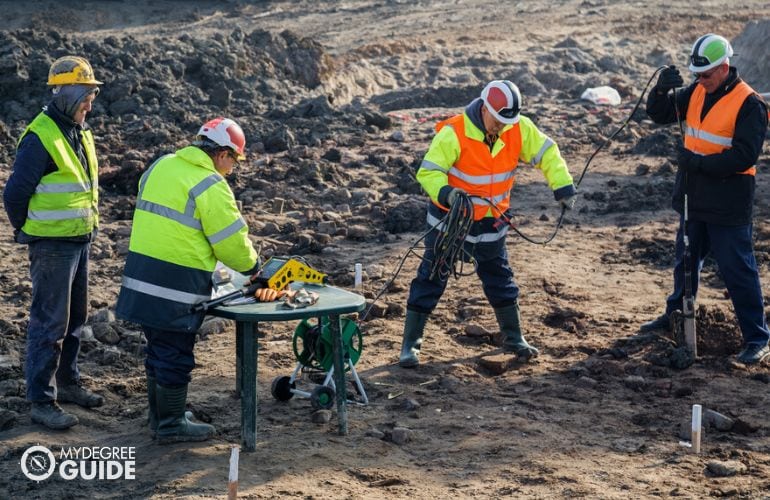
A geographic information systems (GIS) career could entail solving real-world problems and coming up with solutions using geographic data and samples.
Editorial Listing ShortCode:
GIS master’s programs may offer opportunities for professionals to advance in their career or for students to enter the field. Much like with geography masters programs online or on campus, a graduate program in GIS can cater to many different interests, and experience with GIS can be useful for a range of career paths.
Universities Offering Online Masters in GIS Degree Program
Methodology: The following school list is in alphabetical order. To be included, a college or university must be regionally accredited and offer degree programs online or in a hybrid format.
Elmhurst University
Elmhurst University offers an MS in Geographic Information Systems that can be earned online, typically in 2 years. The program is flexible and part-time, with classes offered in 8 week sessions. It offers online access to GIS software. To graduate, students must create a thesis, capstone project, or portfolio.
Elmhurst University is accredited by the Higher Learning Commission.
Johns Hopkins University
Johns Hopkins University offers an online program for an MS in Geographic Information Systems. It offers concentrations in GIS Programming and Application Development, Geospatial Data Science and Predictive Analytics, and Advanced Geospatial Technology. The program consists of 10 required courses and can usually be completed in 1 to 2 years.
Johns Hopkins University is accredited by the Middle States Commission on Higher Education.
Kent State University
Kent State University offers a Master of Geographic Information Systems that can be earned completely online to help meet the needs of working adults. The degree can potentially be earned in just 2 years. Kent State’s online courses are each 7 weeks long. Students may customize their coursework to better suit their career goals, and the program culminates with a practicum.
Kent State University is accredited by the Higher Learning Commission.
Sam Houston State University
Sam Houston State University offers a Master of Science in Geographic Information Systems. The program offers two tracks, a professional track that is completely online and a traditional track that has some face-to-face components. To graduate, students must complete 30 to 36 credit hours. New students may begin in the fall or spring.
Sam Houston State University is accredited by the Southern Association of Colleges and Schools Commission on Colleges.
University of Arizona
The University of Arizona offers an online program for a Master of Science in Geographic Information Systems Technology. The program requires 30 credits of courses such as Remote Sensing Science, Raster Spatial Analysis, Vector Spatial Analysis, and more. Students can potentially finish the program in 18 months.
The University of Arizona is accredited by the Higher Learning Commission.
University of Cincinnati
The University of Cincinnati offers a Master of Science in Geographic Information Systems. The program is 100% online and requires the completion of 30 credits. Coursework includes Computer Analytical Cartography, Quantitative Geography and Spatial Statistics I and II, Introduction to Remote Sensing, and more.
UC is accredited by the Higher Learning Commission.
University of Denver
The University of Denver offers an online program for a Master of Science in Information and Communications Technology with a concentration in Geographic Information Systems. Terms are 10 weeks long, and students can potentially graduate in just 18 months. GRE and GMAT scores are not needed to apply.
The University of Denver is accredited by the Higher Learning Commission.
University of Southern California – Dornsife
The University of Southern California—Dornsife offers an online program for an MS in Geographic Information Science and Technology. It offers tracks in Spatial Analytics, Spatial Computing, and Spatial Data Management. The program emphasizes hands-on learning and includes fieldwork experiences and courses such as Spatial Databases, Spatial Econometrics, and Spatial Data Acquisition.
The University of Southern California – Dornsife is accredited by the Western Association of Schools and Colleges, the Senior College and University Commission.
University of Wisconsin – Madison
The University of Wisconsin—Madison offers a Master’s in Cartography and GIS with a professional non-thesis option in GIS Development. The program teaches up-to-date technological skills and includes courses such as Graphic Design in Cartography, Spatial Databases, and Interactive Cartography and Geovisualization. Classes can be taken full-time or part-time.
The University of Wisconsin – Madison is accredited by the Higher Learning Commission.
West Virginia University
West Virginia University offers an online program for an MS in Geographic Information Systems and Spatial Analysis. The program requires the completion of 31 credit hours, or ten courses. Each course is 8 weeks long, and the program offers three start dates each year. Prospective students are expected to already have basic knowledge of computer science and statistics.
West Virginia University is accredited by the Higher Learning Commission.
Online Masters in GIS Programs


Geographic information systems (GIS) is the use of computer-based programs to organize, analyze, and display geographic data and information. Professionals working in GIS careers often use geographic data and samples to solve problems and come up with solutions.
Several industries work with GIS professionals, and individuals working in a GIS-related position may coordinate with scientists or engineers. There are many different responsibilities a GIS professional can have depending on the career path they choose.
Here are some examples of GIS-related tasks someone may have in different industries:
- Collecting data on the frequency of earthquakes or floods in a specific area
- Using geographic data to create and update maps for a variety of purposes
- Using data on ecosystem conditions and land-use patterns for conservation purposes
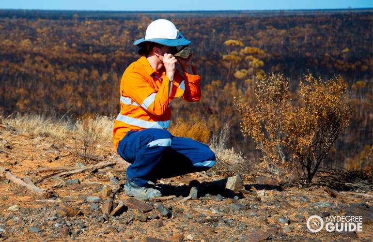
Professionals with a master’s degree in GIS might have the opportunity to work in an outdoor environment, a laboratory, or an office setting. Many positions in the GIS field involve the use of analytical skills and problem-solving techniques.
Students who wish to pursue a masters in GIS might have a background in geospatial science, conservation, planning, or surveying. GIS master programs can help you either enter a GIS career or advance your education and current position in the field. Some common career paths for professionals with training in GIS include:
- Geographer
- Cartographer
- Forester
- Conservation scientist
- Surveyor
These are just a few positions that graduates might pursue following a GIS masters program. There might be other career field options available to you outside of these positions.
Geographic Information Systems Careers & Salaries

Pursuing a career in GIS may allow you to seek out a variety of positions in several different industries. GIS professionals are often found in industries such as government, business, or conservation. These positions can involve working in an office setting or can be more hands-on in an outdoor work environment.
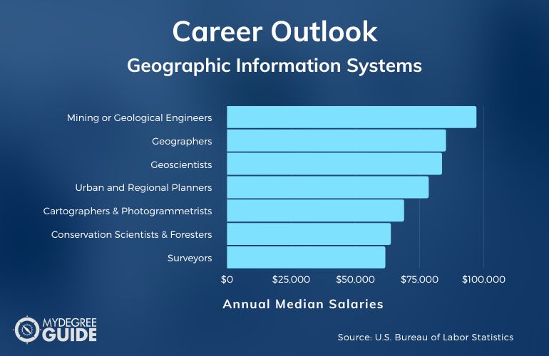
According to the Bureau of Labor Statistics, here are some career paths related to the study of geographic information systems.
| Careers | Annual Median Salaries |
| Mining or Geological Engineers | $97,090 |
| Geographers | $85,220 |
| Geoscientists | $83,680 |
| Urban and Regional Planners | $78,500 |
| Cartographers and Photogrammetrists | $68,900 |
| Conservation Scientists and Foresters | $63,750 |
| Surveyors | $61,600 |
| Environmental Scientists and Specialists | $76,530 |
| Geological Technicians | $48,310 |
| Surveying and Mapping Technicians | $46,910 |
Availability for these careers might differ depending on your level of experience and training, education, and where you live. Salaries can also vary based on these factors.
Some careers are more technical in nature, while others involve collecting samples and data in the field. If you like analyzing data and samples, you may prefer working in an office or laboratory setting. Professionals who have an interest in being hands-on and working outdoors might prefer a GIS career that involves more fieldwork.
Master of GIS Curriculum & Courses


A GIS masters program often has a more advanced curriculum on GIS software and programming and research methodology used in different industries.
Here are some common core and elective courses that may be offered in GIS masters programs:
- GIS Database Development: You can learn about different GIS databases used in the field and how to create them by collecting, recording, and using spatial data.
- Geospatial System Analysis and Design: This course explores systematic approaches used for design and implementation of geographic information systems.
- Geographical Information Analyses: You’ll explore analytical methods used for analyzing geospatial data, such as surface analysis and point pattern analysis.
- Foundations of Geospatial Intelligence: This introductory course provides you with foundational knowledge of geospatial intelligence and how it’s applied in different industries.
- GIS Programming and Software Development: In this course, you can explore various geospatial programming and software used to perform a variety of GIS tasks.
- Geographic Information Science: This course gives an overview of the general principles of geographic information science and how to apply them to labs using GIS software.
- Cartography and Visualization: You can learn different theories and practices involved in cartographic design that involve visual thinking and communication with GIS software.
- Remote Sensing and Imagery: You can learn the concepts of image processing using remotely sensed images, and you can explore different imagery collection methods.
- Geospatial Technology Project Management: You’ll learn about project management principles, which can be applied to the design and implementation of GIS.
- Advanced Spatial Analysis: This course builds upon the basic concepts of spatial analysis by reviewing geospatial data acquisition systems and teaching you about advanced spatial analysis tools.
Coursework can vary depending on the program and school. Researching different schools can help you get an understanding of which programs might best align with your specific interests.
Master in GIS Admissions Requirements


Admission requirements can vary depending on the program and school you choose. Common admission requirements for a GIS master program include:
- Bachelor’s degree
- Copy of official transcripts
- Minimum GPA (typically 3.0 or above)
- Personal statement
Schools often request official transcripts from your prior education so they can see what coursework you’ve completed and what your GPA was. Some programs may not have a minimum GPA requirement. Obtaining a bachelors degree in a GIS-related field is one of the first steps in pursuing a masters degree in GIS.
Online GIS Masters Programs Accreditation


The accreditation status of a prospective school is an important factor to consider when exploring masters programs in GIS. Regional accreditation ensures that a school is meeting quality performance and educational standards.
Receiving a graduate degree from an accredited school or program has a number of benefits. Credits earned at an accredited school have a higher chance of transferring to another school. In addition, certification processes often include receiving an education from an accredited school.
Your school’s accreditation status can also affect your eligibility for federal student aid. You can check out a list of regionally accredited institutions on the US Department of Education’s website.
Financial Aid and Scholarships


Financial aid and scholarship opportunities can help eligible students cut down the cost of tuition and other school expenses.
State and federal aid may be available for students who are able to prove demonstrated financial need. To find out if you’re eligible for federal aid, you can fill out and submit the Free Application for Federal Student Aid (FAFSA) online. Scholarships are monetary awards given to select students who apply based on certain criteria. Some scholarships may be specific to certain schools or programs.
Merit scholarships are centered around non-income-based rewards. Students may receive scholarships based on academic or athletic performance. Scholarships can also target certain groups of people or be made available to students who have specific interests.
What Can You Do with an Online GIS Masters Degree?


A master’s in GIS is a versatile degree, as there are various career paths and industries related to this field. Environmental and government positions are common career paths for GIS students.
According to the Bureau of Labor Statistics, 62% of geographers work for the federal government. Individuals interested in analyzing data for geographic measurements or map making might pursue work as surveyors or cartographers. Other GIS professionals may work as urban or regional planners, GIS analysts, or GIS managers.
Depending on their position, workers in this field can find themselves in an office, a laboratory, or the great outdoors. Some careers include working in multiple environments.
How Long Is a Masters Program in GIS Online?
GIS master’s programs can vary in length depending on their number of credit hours and whether a thesis is required. Most masters programs can be completed in 1 or 2 years with full-time study.
If a GIS masters program consists of 36 credit hours, it may be completed in 1 year if you study full-time, including during the summer. Enrolling part-time will often take you longer to complete your masters degree. A thesis component could also add on an extra semester or two to the length of your program.
Is a Masters in GIS Worth It?

Yes, a masters in GIS is worth it for many students. Working in GIS can be a rewarding experience for individuals interested in solving problems that can help humanity advance.
Expertise in geographic information systems (GIS) can be applied to several industries and careers. It’s a versatile field that can cater to a wide variety of interests. Careers related to this field can include surveyors, cartographers, geographers, GIS analysts, and urban or regional planners.
According to the Bureau of Labor Statistics, life, physical, and social science occupations are expected to see 8% job growth over the next ten years.
Getting Your Masters in GIS Online


Much like with on-campus or online geography degrees, GIS masters programs could be a rewarding educational experience for students who are passionate about helping people and the world.
It can be an interesting field for individuals who wish to collect geographic data and samples. GIS is used for a variety of purposes, so expertise in this field could also lead to a variety of career paths. Current GIS professionals can also pursue a masters degree online to further their education and qualifications in the field. A graduate degree could possibly lead to an increase in job opportunities and earning potential.
If you’re ready to take the next step in your educational journey, you can start by exploring accredited institutions that offer online GIS masters programs.